museum-digitalsachsen
CTRL + Y
en
Schloss- und Stadtmuseum Hoyerswerda [SH_18.6.2.12]
https://sachsen.museum-digital.de/data/sachsen/resources/documents/202208/03122950035.pdf (Schloss- und Stadtmuseum Hoyerswerda CC BY-NC-SA)
Provenance/Rights: Schloss- und Stadtmuseum Hoyerswerda (CC BY-NC-SA)
1 / 1 Previous<- Next->

Darstellung des Regierungsbezirkes Liegnitz mit zahlreichen Informationen

Contact Cite this page Data sheet (PDF) Calculate distance to your current location Archived versions Mark for comparison Graph view

Description

Die Karte bildet den Königlich Preussischen Regierungsbezirk Liegnitz mit seinen 19 Kreisen ab. Die topografische Karte enthält Informationen über den gesamten Regierungsbezirk, von der Oberfläche bis zur Wirtschaft.

Material/Technique

Papier/Druck

Measurements

H x B: 59,2 x 47 cm

Schloss- und Stadtmuseum Hoyerswerda

Object from: Schloss- und Stadtmuseum Hoyerswerda

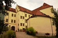
Seit 1952 ist im Hoyerswerdaer Schloss das Stadtmuseum mit seinen regional und überregional bedeutenden Beständen untergebracht. Im neuen 'LehrReich'...

Contact the institution

[Last update: ]

Usage and citation

The textual information presented here is free for non-commercial usage if the source is named. (Creative Commons Lizenz 3.0, by-nc-sa) Please name as source not only the internet representation but also the name of the museum.
Rights for the images are shown below the large images (which are accessible by clicking on the smaller images). If nothing different is mentioned there the same regulation as for textual information applies.
Any commercial usage of text or image demands communication with the museum.